Enquire about Robot

Simply fill up the form, our team will then reach out to you to connect to the relevant parties who can help facilitate your request.

Brand & Model
All fields required. Refer to our privacy policy for questions.
Thank you! Your submission has been received!
Oops! Something went wrong while submitting the form.

BOZBEY

Autonomous VTOL UAV with 6-hour endurance, 80 km range, and modular ISR payloads for surveillance, reconnaissance, and infrastructure monitoring missions.
Software Type
Closed Source
Software Package
Uses HAVELSAN autonomous flight software.
Aparobot Readiness Score
ARS?
0
...
Actuators
Uses electric propulsion system.
Compiute
Sensors
Equipped with EO/IR camera systems, Laser Range Finder (LRF), GNSS / INS navigation system, and Anti-jamming CRPA GNSS.
Max Op. time
360
mins

Recent Robot Videos

*Aparobot claims no ownership of videos posted unless otherwise stated.
Description text
Date

Robot Brief

The BOZBEY is a medium-class sub-cloud autonomous VTOL fixed-wing unmanned aerial vehicle (UAV) developed by HAVELSAN to meet the operational needs of modern military forces. Designed for long-endurance intelligence, surveillance, and reconnaissance (ISR) missions, BOZBEY combines vertical take-off and landing capability with a gasoline-powered fixed-wing propulsion system, enabling extended flight duration and large-area coverage. The aircraft features a 4-meter wingspan, modular payload integration, and robust autonomy systems, allowing it to operate in complex environments and adverse weather conditions while delivering real-time intelligence data.

Use Cases

  • ISR (Intelligence, Surveillance & Reconnaissance):
    Collects real-time intelligence using EO/IR/LRF sensor systems.
  • Border & Coastal Surveillance:
    Monitors large areas for intrusion, smuggling, and security threats.
  • Target Detection & Tracking:
    Identifies, tracks, and estimates coordinates of targets for tactical operations.
  • Disaster Response & Search Operations:
    Supports post-disaster assessment, search and rescue, and situational awareness.
  • Infrastructure & Environmental Monitoring:
    Inspects pipelines, power lines, and monitors environmental conditions.

Industries

  • Defense & Military:
    Tactical ISR, artillery spotting, and battlefield intelligence.
  • Homeland Security:
    Border patrol, counter-terrorism, and public safety operations.
  • Disaster Management:
    Rapid aerial assessment and coordination support during emergencies.
  • Energy & Infrastructure:
    Inspection of pipelines, power grids, and industrial assets.
  • Agriculture & Environment:
    Crop monitoring and environmental surveillance.

Specifications

Length
-
2000
mm
Width
-
4000
mm
Height (ResT)
-
mm
Height (Stand)
-
mm
Height (Min)
-
mm
Height (Max)
-
mm
Weight (With Batt.)
-
40
kg
Weight (NO Batt.)
-
kg
Max Step Height
-
mm
Max Slope
+/-
-
°
Op. Temp (min)
-
-10
°C
Op. Temp (Max)
-
60
°C
Ingress Rating
-
No items found.

Intro

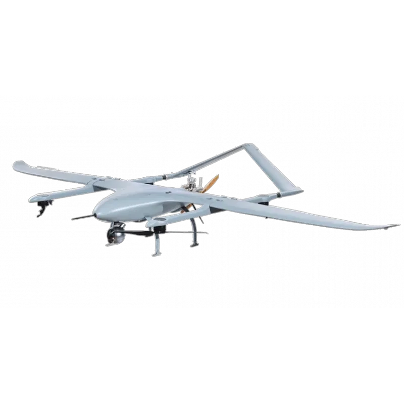
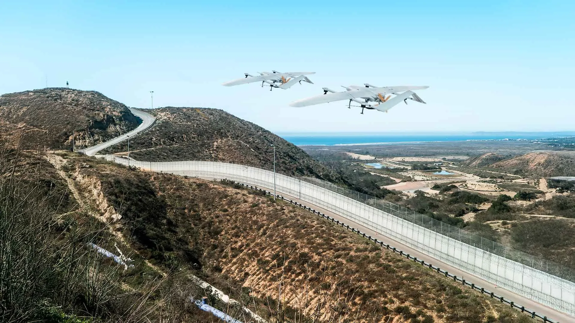
The BOZBEY UAV is a sub-cloud autonomous aerial platform engineered for extended-duration ISR missions in both military and civilian environments. Developed by HAVELSAN, the system is designed to operate effectively below cloud cover, enabling reliable intelligence gathering in environments where visibility, responsiveness, and persistence are critical. The platform operates at a ceiling altitude of 11,000 ft and a typical operating altitude of 8,000 ft, positioning it optimally for continuous surveillance, target tracking, and real-time situational awareness across large operational areas.

The aircraft features a hybrid propulsion architecture, combining electric motors for vertical take-off and landing with a gasoline-powered engine for forward flight, which serves as the primary propulsion system. This configuration allows BOZBEY to launch and recover vertically without runway infrastructure while achieving significantly extended endurance. With a flight endurance of up to 6 hours, the platform is well-suited for long-duration missions such as border patrol, infrastructure monitoring, and persistent reconnaissance operations.

BOZBEY is engineered for operational reliability in varying environmental conditions, with wind resistance capabilities of up to 15 knots during take-off and landing and up to 25 knots during cruise flight. This ensures stable performance during both vertical and forward flight phases, enabling mission continuity even in moderate wind conditions. The aerodynamic design and propulsion system work together to maintain efficient and stable flight across extended operational ranges.

The UAV incorporates a fully autonomous flight system, enabling it to execute missions independently, including waypoint navigation, target tracking, and automatic return-to-home in case of communication loss. It is equipped with EO/IR/LRF sensor systems, allowing day and night surveillance, precise target detection, and coordinate estimation. Additionally, BOZBEY integrates anti-jamming GNSS capabilities with CRPA technology, ensuring reliable navigation in contested or electronically degraded environments. Designed for interoperability within HAVELSAN’s Digital Troops ecosystem, the platform can operate collaboratively with other unmanned systems, supporting coordinated and network-centric mission execution.

Connectivity

  • Data link range up to 80 km.

Capabilities

  • Vertical Take-off and Landing (VTOL):
    Enables runway-independent deployment in confined or remote areas.
  • Long-Endurance Flight:
    Gasoline propulsion allows missions of up to 6 hours.
  • Autonomous Mission Execution:
    Supports fully autonomous flight including navigation and landing.
  • Modular Payload Integration:
    Supports ISR sensors and mission-specific payload configurations.
  • All-Weather Sub-Cloud Operation:
    Operates effectively below cloud cover in day/night and adverse conditions.
  • Multi-System Interoperability:
    Can operate alongside other unmanned systems in coordinated missions.
  • Anti-Jamming GNSS (CRPA):
    Equipped with multi-antenna GNSS system to resist signal jamming.